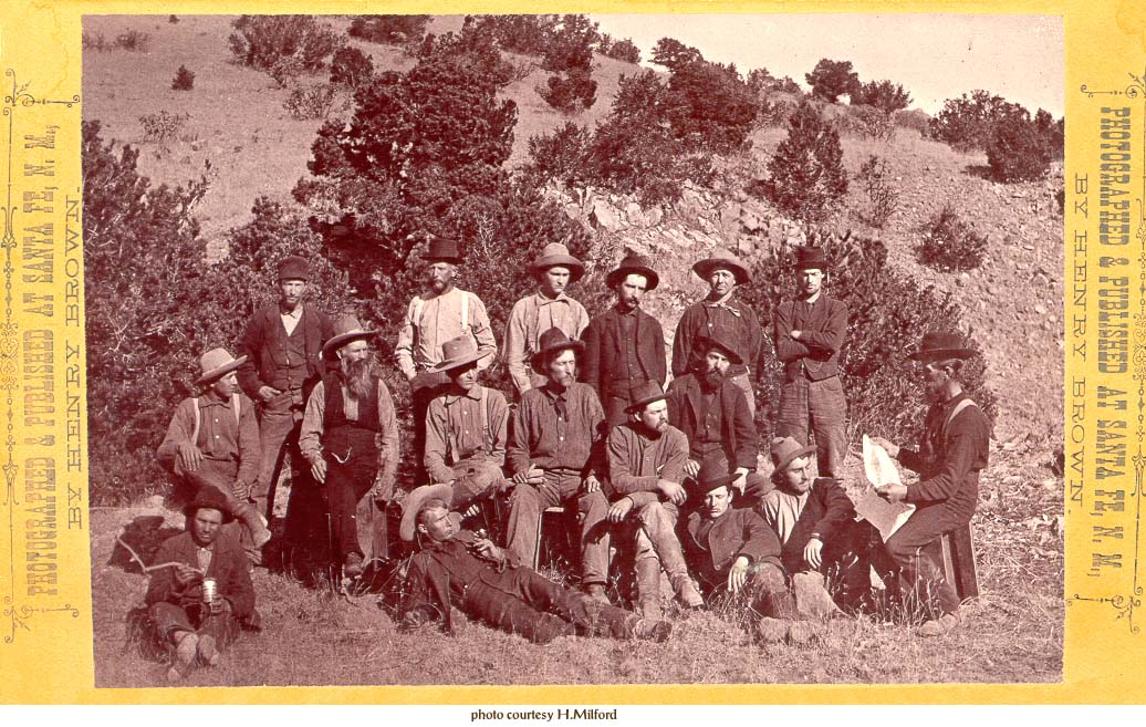
Photos of Miners in the Cerrillos Hills - 1880
ABOUT THESE PHOTOGRAPHS
These photographs of the Galisteo and Cerrillos Mining Districts were taken in the Spring of 1880 by George C. Bennett . Some of the stereo cards state that a five day trip was made to the district for the purpose of making these photos. The exact date of the trip is not known, but was in the spring of 1880, as the photo of Carbonateville does not show even the start of the two story hotel that was constructed in May, 1880, in the foreground of the area photographed.
Bennett worked for W. Henry Brown who had a photographic studio in Santa Fe, and the photos were reissued with different numbers in different sets several times during the 1880s. Photo cards were issued under the name of Bennett or Brown as well as both of them, but scholars at the Museum of New Mexico Photographic Archives believe all photos were taken by Bennett.
Additional early photos will be added to this photo archive as they are located and permission obtained for their inclusion. If you have or know of other photos please contact the Amigos.
(reverse) HENRY BROWN, PHOTOGRAPHER Stereoscopic Views of New Mexico a Specialty. West Side Plaza - Up Stairs, Santa Fe, N.M.
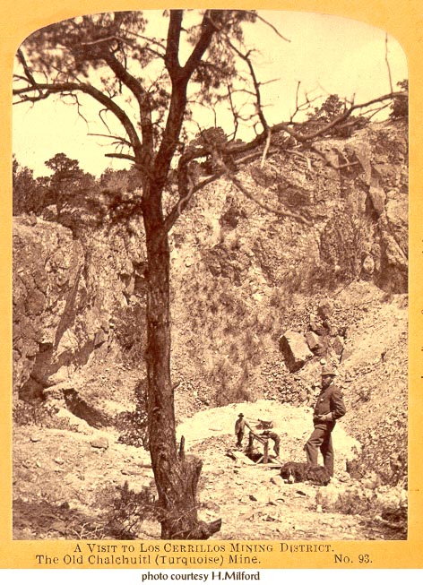
This photograph is of the West Pit of Mt. Chalchihuitl looking northeast. At the bottom of the pit is the new shaft started by D. C. Hyde.
(the following text is on the reverse)
Editor's note: This text is reproduced here for its historical interest. It is representative of the time in which it was written and reflects the ethnic biases of that age. It also contains some historical inaccuracies.
A FIVE DAYS VISIT TO THE SILVER MINING DISTRICT OF LOS CERRILLOS, NEW MEXICO
Los Cerrillos is the name of a group of hills about twenty miles south-west of Santa Fe, that has recently become popular as a mining camp, and interesting historically, on account of old mines. (The name is from the Spanish, meaning eminences, and seems appropriately given, for in a view that includes also the Placer and Sandia Mountains they appear best ordinary hills. However, the comparison of their heights, which is from two hundred to one thousand feet above adjacent plains and valleys, they are of sufficient altitude from which to obtain long views of a surrounding country and a person will be well rewarded for the trouble of ascending any of Los Cerrillos, in a sight of varied New Mexico landscape.) The area of the group, including ridged and gulched foothills, is 25 or 30 square miles. The region is important from the fact of a surface showing of a mineral belt of veins or lodes of valuable ores; and it is an interesting tract because of ruined and filled up old Indian and Spanish mines, that are being reopened by prospectors and miners that have crowded into the district within a year. There are old mines of "Chalchihuitl", and silver. The former are said to have been worked by Indians before the discovery of America, and the latter were worked under Spanish authority about two hundred years ago. The reopenings disclose old passages, and the ancient tools, pottery, and rude implements with which the Aztec, Pueblo, or Spaniard delved for "underground treasure" long ago.
"Chalchihuitl", the Indian name for turquoise, is a mineral much prized by the Indians. There is no historical date of commencement to mine for it here in Los Cerrillos, though probably it was hunted for upon the surface long before the Spanish conquered and forced the natives to work it out of the rocks for the nobility of Europe to wear. There are many filled and partly filled up old mines or workings for metal and the pretty colored stone, turquoise.
History accounts a revolt among the Indians who, in the year 1680, threw off the yoke of Spanish authority, drove their old task-masters out of the courntry, and filled up the old mines that they had been compelled to work. Several years later the Indians were reconquered, and though their conquerors were complete masters of the country, otherwise there is no account of the natives being enslaved to work these mines again. Voluntarily the Indians come to the old dumps of the turquoise mines and work over the ground in a rude way to get bits of the mineral that may have escaped the notice of the miners in the past.
The old turquoise mine, now being opened by an enterprising person, is an immense work; especially so when a consideration is had of the rude facilities in use in the "booming times" of two hundred years ago. It is known that the Indians regard this mine, and the pretty blue pieces found there, with a kind of sacredness. And well they might if traditons are will founded - and some things lately mined are corroborative - of the 25 natives that were buried alive years ago in a slide of rocks upon them in the great shaft of turquoise hill. These turquoise mines are said to be the only known ones in America. Some of the most valuable samples now in the crown jewels of Spain, it is said, were taken from these old mines. Only one or two out of many in this district are being worked just now, other than such as the Indians yet do of scratching with hands or sticks amongst old dumps for bits of a bright color, which they prize as highly as their forefathers did.
There are several other shafts and "open cuts" mined evidently for gold, silver, and lead, probably by Spaniards, Mexicans, and later by Americans. These workings are curiously made, deep shafts showing no marks of drills or powder, yet in rocks hard enough for the modern miners to employ such aids. Stone hammers found in several old workings attest the rude ways in which work of mining was done long ago. Poles notched for steps, reaching from one rock stage to another in these unshapely shafts, were the ladder ways, and likely enough we see today in those old worn notches footprints of an enslaved Pueblo or peoned Mexican, who carried the ores out of these shafts up those ways with the burden upon their heads.
One year ago a new life started, Phoenixlike, from the ashes of the mineralogical and historical past of this region. To be sure there has been some mining and prospecting done here since the American occupation of the territory, yet, today the hundreds of valuable mining claims, and the numerous camps of organized mining district probably outnumber anything of a like enterprize in times gone by.
In 1680 a visitor to Los Cerrillos might have seen drudgery and servitude of mining for poor pay among those who broke the rocks with unwieldy stone hammers, wooden wedges, and levers. In 1880 he can see numerous new mines upon the sites of old ones, and elsewhere hear the pick blows, the scrape and ring of shovelful, the clinking hammer strokes on drills, and the booming of blasts deep in the fissured hills where work in hopeful earnestness is carried on. The prospectors and miners of this district are generally well pleased and reasonably expectant of rich returns for their outlays upon claims, as no silver district heretofore discovered discloses such a great number of true fissure veins in so limited an area of country. The ores of this district run from 15 to 1500 ounces of silver to the ton, with occasionally gold, from a trace to 6 or 8 ounces to the ton; and this from only what might properly be called surface workings, so that according to all experience heretofore in silver mining, with a sufficient depth, the mines of this district may reasonably be expected to surpass in richness anything ever before discovered.
The signature on the back of this photograph is that of Governor L.B. Prince and implies he is giving it to O'Neil who was his mining partner on several Cerrillos claims including the "Blue Bell" turquoise claim.
(reverse) A FIVE DAYS VISIT... (for full text see Mt. Chalchihuitl Mine photo) and signatures "M. O'Neil Jr" and "L.B. Prince"
(front) Among the Ancient and Interesting Scenery of New Mexico. Photographed and Published at Santa Fe, N.M. by W. Henry Brown
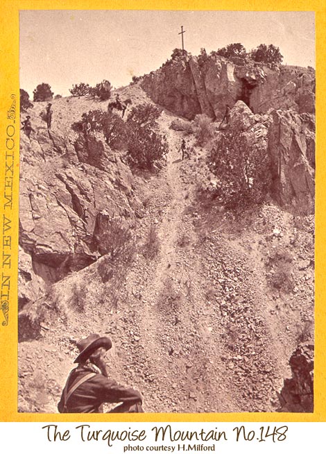
Looking east across the great pit on the western face of Mt. Chalchihuitl. Note the cross erected by D. C. Hyde on top of Mt. Chalchihuitl. The man in foreground is in many of the photos and may be Bennett or his brother.
(text on reverse)
A Trip from Trinidad, Col., Through New Mexico to Paso-del-Norte, Mexico.
(partial) From Lamy southward again along the valley of the Galisteo, between the rich, thriving mining districts of Los Cerrillos and New Placer, along at the very foot of the "Devil's Throne", (one of the Los Cerrillos mountains) with a fair view of the not very distant New Placer mountains, and emerging upon the broad valley of the Rio Grande at the quaint Indian Pueblo of Santo Domingo we dash along past well cultivated fields and orchards and past the ancient ruined Pueblo of Cia, situated on the top of the high bluff across the river; past the picturesque pueblo of San Felipe, with the river at its very feet and a high bluff immediately back of it. And here is Albuquerque, with its brand new railroad town, and queer "old town", its broad valley and fine view of the distant Sandia mountains.
(front) Along the Line of the A.T.&S.Fe R.R. in New Mexico.
Photographed & Published at Santa Fe, N.M., by Henry Brown.
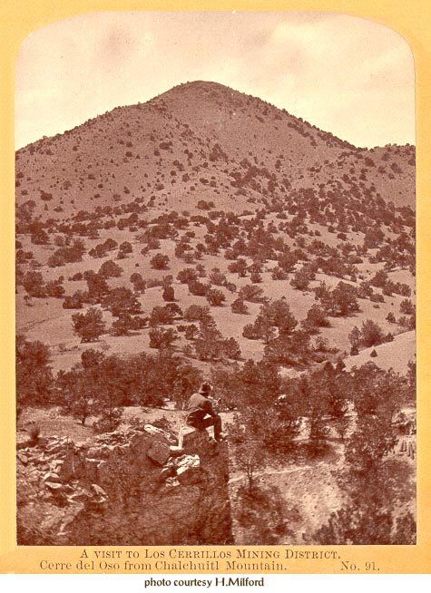
Overlooking the western pit of Mt. Chalchihuitl, toward Cerro del Oso (Grand Central Mountain). The man in the foreground is sitting about 15 feet from the cross on top of Mt. Chalchihuitl seen in the previous photo (No. 148).
(reverse) A FIVE DAYS VISIT... (for full text see Mt. Chalchihuitl Mine photo)
(front) Among the Ancient and Interesting Scenery of New Mexico. Photographed and Published by G.C. Bennett, Santa Fe, N.M.

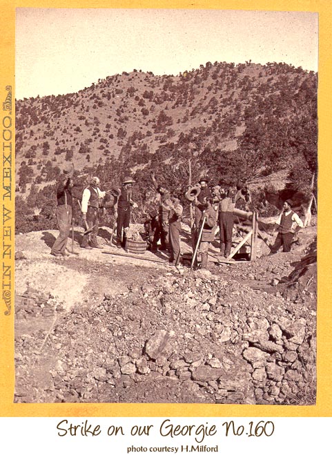
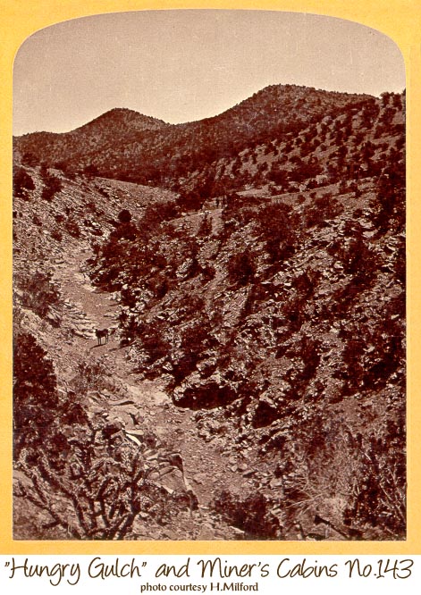
Miners examining ore taken from the "Our Georgie Mine." This mine's name was changed prior to 1900 to the Tom Payne Mine and was the last producing mine in the district, closing in 1957. The trail or road seen in the background (upper left) connected this valley, Hungry Gulch, to the new town of Bonanza.
The name of the old Spanish site of "Los Cerrillos" at the north end of the district was changed to "Bonanza" in 1879. Bonanza is the Spanish mining term for rich ore and was incorporated before the start of the Cerrillos mining rush in 1879 into American English as meaning a rich place or something good. The change of the name of the Alamo Creek area from "Los Cerrillos" to "Bonanza" in 1879 led to the selection of the name "Cerrillos Station" for the rail road stop at the southern end of the district.
The hand cranked windlass was used to hoist a half-barrel sized buckets of ore. It is basically like a old well crank except that it was fitted for two men to crank. The bucket was overfilled for the photo.
reverse) HENRY BROWN, PHOTOGRAPHER Stereoscopic Views of New Mexico a Specialty. West Side Plaza - Up Stairs, Santa Fe, N.M.
(front) Along the Line of the A.T.&S.Fe R.R., in New Mexico. Photographed & Published at Santa Fe, N.M., by Henry Brown.
This photo was taken minutes before or after the (previous) photo of the Our Georgie Mine in Hungry Gulch.
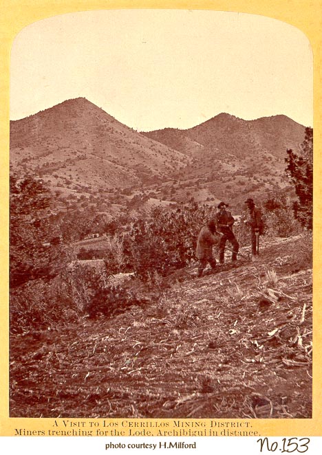
How the Spanish name for this mountain became Archibeque (with various spellings) is not known. This family name comes from Jean L'Archeveque who was born in Bayonne, France, and joined the La Salle Expedition at the age of 13. He played a role in the killing of La Salle and after his rescue or capture in Texas was taken to Mexico City. Fray Angélico Chávez, in Origins of New Mexico Families (Univ. of Albuquerque in collaboration with Calvin Horn Publishing, 1973, n. 3, p. 129), gives a contemporary source saying that he was condemned to work in the mines. In 1695, L'Archeveque was recruited in the silver mining town of Zacatecas to immigrate to New Mexico. This is the same year that Governor Vargas reopened the Cerrillos silver and lead mines, so there could be a connection. Jean's name was Hispanicised into Juan de Archibeque and he has numerous descendants in New Mexico.
(reverse) A FIVE DAYS VISIT... (for full text see Mt. Chalchihuitl Mine photo)
(front) Among the Ancient and Interesting Scenery of New Mexico. Photographed & Published at Santa Fe, N.M., by W. Henry Brown.
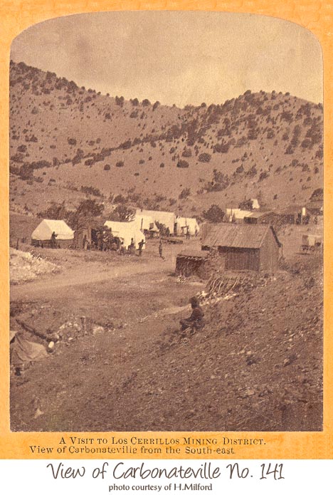
The mining camp of Carbonateville, looking slightly west of due north. Cerro de la Cosena (also known as Mt. McKensie) is in the background, the main peak out of the picture to the left. In May of 1880, in the open space between the seated person and the small adobe structure, construction was begun on a two story hotel (Weekly Santa Fe New Mexican, May 24, 1880); thus this and other Bennett photos must date prior to that. Note the photographer's wagon on the extreme right of the photo.
A photo of this location today.
(reverse) A FIVE DAYS VISIT... (for full text see Mt. Chalchihuitl Mine photo)
(front) Photographed and Published at Santa Fe, N.M., by Bennett & Brown.
Looking east with one of the miner's cabins on the other side of the valley at Purdin's Camp, the only mining camp in the Galisteo Mining District. The Galisteo Mining District was absorbed later in the year of 1880 into the Cerrillos Mining District.
(reverse) A FIVE DAYS VISIT... (for full text see Mt. Chalchihuitl Mine photo)
(front) Among the Ancient and Interesting Scenery of New Mexico. Photographed & Published by G.C. Bennett, Santa Fe, N.M.
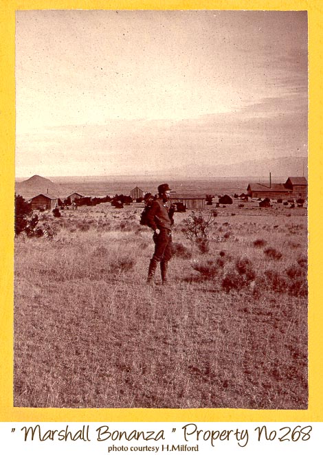
Looking north at the Sangre de Cristo Mountains in the distance (Santa Fe is at their base), and the Marshal Bonanza Mill and cabins in the middle ground. This mine had been acquired by Santa Fe businessmen and was one of the first to see major development. They founded the town at the base of the hill (Bonanza Hill, in the distance at the left edge of the photo), and changed the area name from Los Cerrillos to Bonanza in 1879.
Real de Los Cerrillos, the mining camp founded by Governor Vargas in 1695, was about a quarter mile west of Bonanza at a major spring along Los Cerrillos (Bonanza) Creek.
(reverse) A Trip from Trinidad, Col., Through New Mexico... (for text see The Turquoise Mountain)
(front) Along the Line of the A.T.&S.Fe R.R., in New Mexico. Photographed & Published at Santa Fe, N.M., by Henry Brown
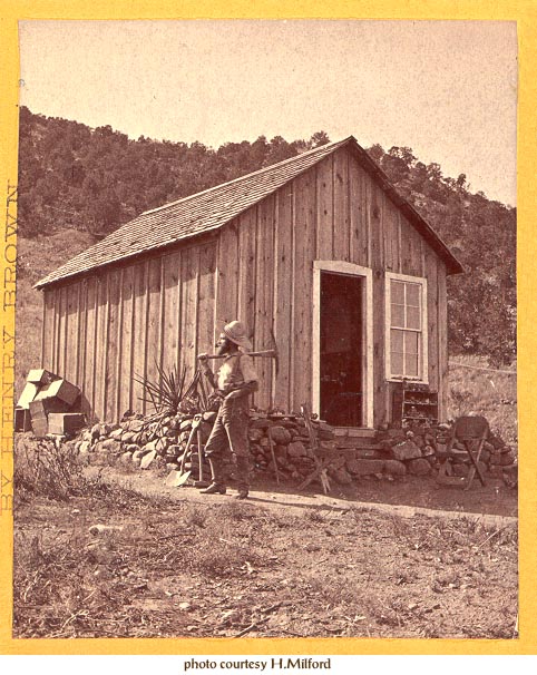
This miner's cabin was probably photographed because it was one of the fanciest homes in the southern part of the district in 1880. The wooden boxes stacked next to the house are probably from canned food, as most miners still used black powder, which came in cans, rather than dynamite, which came in boxes.
(reverse) A Trip from Trinidad, Col., Through New Mexico... (for text see The Turquoise Mountain)
(front) Photographed & Published at Santa Fe, N.M., by Henry Brown.
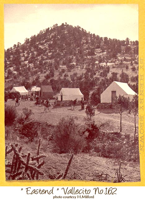
Vallecitos ("little valleys") was a common place name in the Cerrillos Hills and elsewhere in New Mexico. This Vallecitos is in the northern part of the Cerrillos Hills, part of Hungry Gulch. The camp is amazingly tidy. Was it cleaned up for this photograph, or is it because this camp is very new, not more than a month or two old?
(reverse) A Trip from Trinidad, Col., Through New Mexico... (for text see The Turquoise Mountain)
(front) Photographed & Published at Santa Fe, N.M., by Henry Brown.
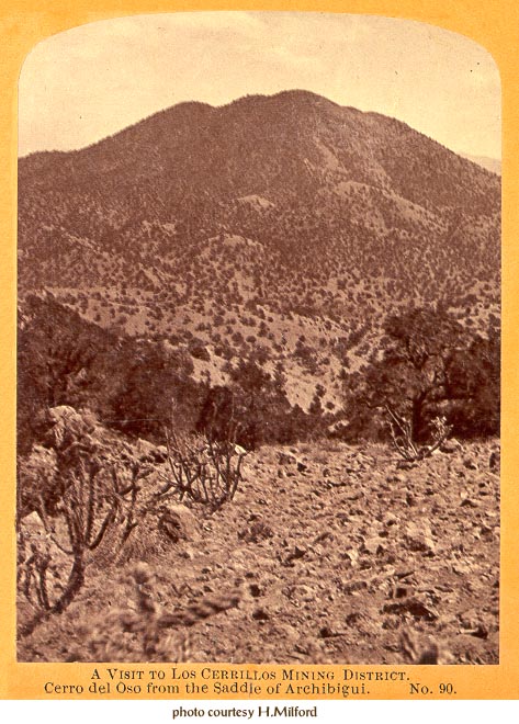
Today Cerro del Oso is more widely known as Grand Central Mountain. The change from the Spanish name Cerro del Oso (Hill of the Bear) to Grand Central Mountain probably occurred due to the major mining effort on this hill. The Grand Central Tunnel Company tried to dig a tunnel all the way through this mountain in 1880-1. One of the founders of the Grand Central Tunnel Company and a major promoter of the district to investors in New York was Henry M. Atkinson, Surveyor General of New Mexico.
(reverse) A FIVE DAYS VISIT... (for full text see Mt. Chalchihuitl Mine photo)
(front) Among the Ancient and Interesting Scenery of New Mexico. Photographed and Published at Santa Fe, N.M., by Bennett & Brown.
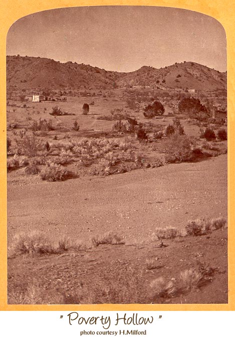
Poverty Hollow is where the Cerrillos reservoir (silted-up) is presently situated, a short distance north of what is now called Poverty Flats. Note the photographer's wagon alongside the tent. The large number of adobe houses is indicative of pre-1880 occupation of the site as most miners still lived in tents. In the foreground is the San Marcos arroyo.
(reverse) A FIVE DAYS VISIT... (for full text see Mt. Chalchihuitl Mine photo)
(front) Among the Ancient and Interesting Scenery of New Mexico. Photographed & Published by G.C. Bennett, Santa Fe, N.M.
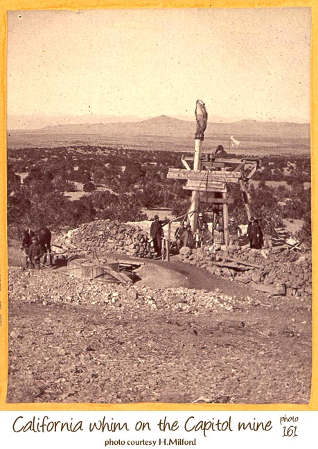
The horse-powered whim was the most complex and powerful of the hoisting device prior to the steam engine. The Marshal Bonanza may have gotten a steam engine later in 1880. Horse whims had the horse walk around in a circle and wind the hoisting rope around a large barrel-type drum. The Spanish name for the device was "malacate", but they were used throughout Europe. In New Spain, malcates (horse whims) were used mainly to hoist water out of the mines. Though called here a California Whim, it has the rope winding drum above ground level like the Spanish malacate, rather than below ground level like the majority of U.S. variations of the device. It could hoist a full whisky barrel of ore (visible between posts of headframe) as opposed to only a half-barrel by the hand powered windlass seen in the Our Georgie photos.
The Capitol Mine was on the west slopes of Santa Rosita Mountain, a half mile west of the Marshal Bonanza Mine and was located by C. M. Purdin (namesake of Purdin's Camp) and A. N. Wiser and was 120 feet deep in July 1880. Its great depth compared to the other mines in 1880 was why it needed a horse whim. Tetilla Peak is in the distance, and beyond it the gorge of the Rio Grande.
reverse) A Trip from Trinidad, Col., Through New Mexico... (for text see The Turquoise Mountain)
(front) Photographed & Published at Santa Fe, N.M., by Henry Brown.
Bennett probably took a picture of this small mine as it was owned by his brother and himself and he thought it might help them sell the mine.
(reverse) A FIVE DAYS VISIT... (for full text see Mt. Chalchihuitl Mine photo)
(front) Among the Ancient and Interesting Scenery of New Mexico. Photographed and Published by G.C. Bennett, Santa Fe, N.M.
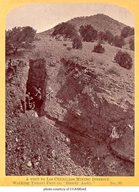
These photos were staged as most photos were at this time in history. It is unlikely that miners carried the guns shown in the photos.
(front) Photographed & Published at Santa Fe, N.M., by Henry Brown.
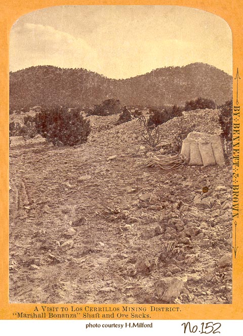
Marshall was an early miner in the district and sold this claim to Santa Fe businessmen. He sold other claims to prominent people including Governor Lew Wallace. The photo only shows piles of waste rock from the shaft and sacked ore ready to be taken to the smelter in Bonanza.
reverse) A FIVE DAYS VISIT... (for full text see Mt. Chalchihuitl Mine photo)
(front) Among the Ancient and Interesting Scenery of New Mexico. Photographed and Published at Santa Fe, N.M. by Bennett & Brown.
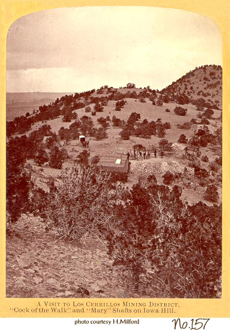
The Cock-of-the-Walk is the mine in the foreground with the windlass and men, and the Mary Mine is further away on extreme right of the photo. Both mines had old workings on them and are two of the forty mines reported as Old Spanish Mines in the district. The road from Bonanza to Hungry Gulch passed next to these two mines, and Santa Rosita Mountain is in the background.
(reverse) A FIVE DAYS VISIT... (for full text see Mt. Chalchihuitl Mine photo)
(front) Among the Ancient and Interesting Scenery of New Mexico. Photographed and Published at Santa Fe, N.M., by W. Henry Brown.
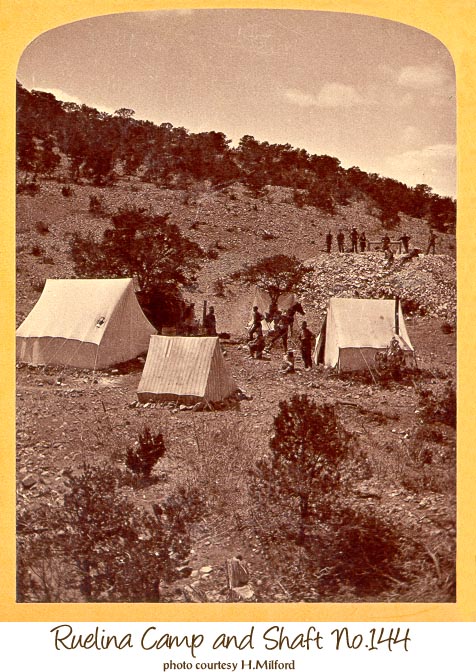
The Ruelena (the name is spelled many ways) Mine along with the Santa Rosa and Mina del Tiro are the only mines whose Spanish names are known. Archaeological evidence has confirmed that it was worked prior to 1700. Several visitors to the area recorded a number of old shafts or declines along its vein with the deepest being 120 feet in 1869. It was reopened and worked for a short time in 1872 by Dr. Enos Andrews along with the Santa Rosa Mine.
Newspapers published a lot of made-up stories about old Spanish mines in the 1880s. Certainly one of the most outrageous statements refers this mine. "... the Rue Alevia (sic. Ruelena) paid $237,000 to the Church of Spain in three months." (Mining World, Las Vegas, 12/1/1882). Mines did not pay tithes to the Church, but if they did this would imply a three month production of 2.34 million dollars for the Ruelena!
(reverse) A FIVE DAYS VISIT... (for full text see Mt. Chalchihuitl Mine photo)
(front) Among the Ancient and Interesting Scenery of New Mexico. Photographed and Published at Santa Fe, N.M., by Bennett & Brown.
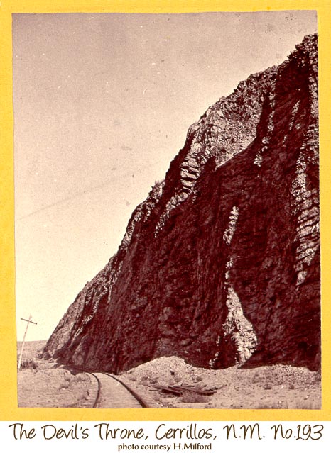
The south side of the Devils Throne has changed very little since this photo was taken only months after the arrival of the Atchison, Topeka & Santa Fe Rail Road.
You can see this site a short distance west of Cerrillos on the Waldo road.
(reverse) A Trip from Trinidad, Col., Through New Mexico... (for text see The Turquoise Mountain) (front) Photographed & Published at Santa Fe, N.M., by Henry Brown.
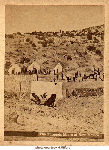
The north end of the mining camp known as Carbonateville, in the spring of 1880, looking west. This location was earlier known as "Dimick and Hart's Camp", but in late 1879 or early 1880 it was renamed after the Carbonate Mine (for its silver carbonate), owned Frank Dimick and Robert Hart. The shed for the steam hoist of Dimick and Hart's Carbonate Lode mine is visible at the top of the ridge in this view. This steam engine was one of the first in the district, and was financed by the sale of interests in the mine to local dignitaries such as U.S. Surveyor General J. Lyman Hayward and the Santa Fe merchants Spiegelberg & Spiegelberg. At the founding of the Cerrillos Mining District, March 27, 1879, Frank Dimick was chosen Recorder & Chairman, and Robert Hart was elected Secretary.
There are several turquoise lodes very near to Carbonateville, and for a brief period in the early-mid 1880s Carbonateville was known as "Turquesa". But the inhabitants of this camp were much more interested in other minerals. Note on the slope between the steam hoist shed and the tents many dark splotches of leaf litter from recently removed trees, probably gone for firewood. There are at least four women visible in this photograph. The many dogs functioned as the town alarm system.(front) Continent Stereoscope Company Publishers - Descriptive Views of the American Continent.
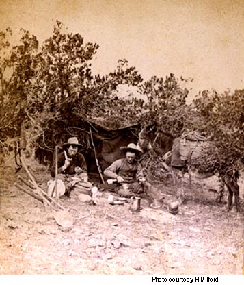
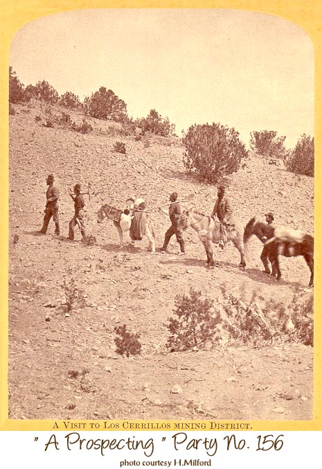
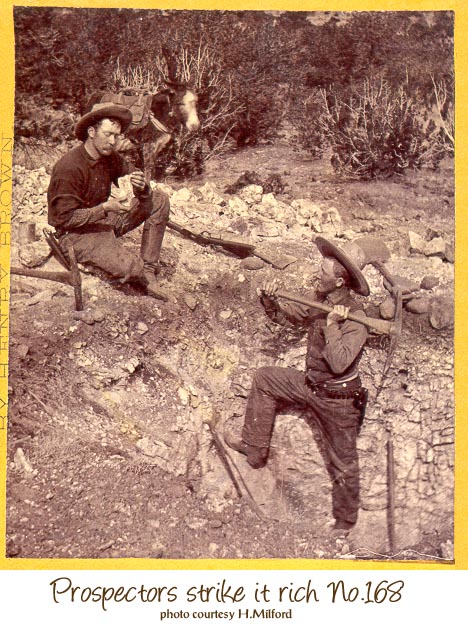
"Prospectors in NM. Pards in camp. No.298" is handwritten on the face of this stereo card. These two men are also the subject of "Prospectors strike it rich No.168". Though staged for the photographer, this is probably a reasonable representation of a temporary miner's camp. Note on the left side, the gunbelt with revolver hanging from the piñon tree and the wooden-handled shovel, two sledge hammers, and an iron pike leaned against the two pickaxes lodged into the ground. The repeating rifle is in the shelter between the two men. Though there is a coffee pot near the fire, the man on the right is pouring his drink from a bottle.
(front) Photographed and Published at Santa Fe, N.M. by Henry Brown.
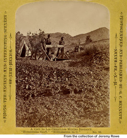
The Homestake mine in the west central area of the Cerrillos Hills; this "galena and copper" mine was located by John W. Martin in 1879 and at the time of this photograph was owned by him as well. The windlass (similar to the mechanism used to lower and raise a bucket of water in a well) was the most common device for moving materials into and out of vertical mine shafts. The man-powered windlass is practical to depths of 75 feet [23 m] or more. In this case two men are transporting a third man up or down the shaft, with a fourth (John Martin?) observing.
Among the Ancient and Interesting Scenery of New Mexico. Photographed and Published by G.C. Bennett, Santa Fe, N.M. [One half of a stereo pair.]
This is the last photograph.